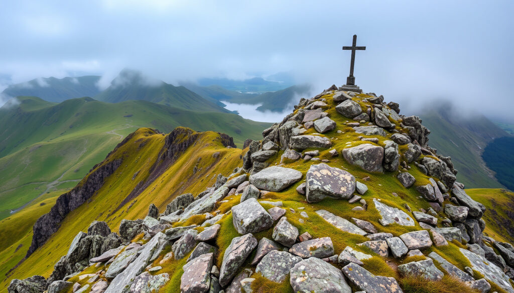
Carrauntoohil: Ireland’s Tallest Mountain – Height & Peaks
Ireland’s tallest mountain, Carrauntoohil, rises 1,038.6 meters in the MacGillycuddy’s Reeks, drawing hikers with steep slopes and rapidly shifting weather. It’s a peak that demands respect — one where rescue teams are called often.
Height: 1,038.6 m (3,407 ft) ·
Location: MacGillycuddy’s Reeks, County Kerry ·
Rank: 1st in Ireland ·
Mountains over 3,000 ft: 14 ·
Mountains over 1,000 m: 4
Quick snapshot
- Carrauntoohil is the highest mountain in Ireland (Encyclopaedia Britannica (geographical reference))
- Located in MacGillycuddy’s Reeks, County Kerry (Wikipedia (crowd-sourced encyclopedia))
- 14 mountains over 3,000 ft (914 m) exist in Ireland (Wikipedia (mountain lists))
- Exact number of deaths on Carrauntoohil — different sources give varying totals (Encyclopaedia Britannica (geographical reference))
- First ascent date — 1765 is recorded, but earlier unrecorded ascents are possible (Encyclopaedia Britannica (geographical reference))
- Annual visitor count — estimates range from 40,000 to 60,000 (Encyclopaedia Britannica (geographical reference))
- First recorded ascent by John Thewles in 1765 (Encyclopaedia Britannica (geographical reference))
- Over 50,000 visitors annually continue to test the Kerry Mountain Rescue Team’s capabilities (The Ireland Walking Guide (hiking reference))
The table below captures the key specs of Ireland’s highest peak.
| Attribute | Value |
|---|---|
| Height | 1,038.6 m (3,407 ft) |
| Mountain Range | MacGillycuddy’s Reeks |
| County | County Kerry |
| Prominence | 1,038.6 m (highest in Ireland) |
| First Recorded Ascent | 1765 (by John Thewles) |
| Number of Mountains Over 3,000 ft in Ireland | 14 |
| Annual Visitors (estimated) | 50,000+ |
Where is the tallest mountain in Ireland?
What is the exact location of Carrauntoohil?
Carrauntoohil sits on the Iveragh Peninsula in County Kerry, southwestern Ireland, at coordinates 51°59′56″N 9°44′34″W (Britannica geographical reference). The summit rises abruptly from the surrounding landscape, a sharp point in a region known for its rugged beauty.
What mountain range is Carrauntoohil in?
It is the crown jewel of the MacGillycuddy’s Reeks, a range formed from red sandstone and heavily sculpted by glaciation (Britannica geological description). Sharp peaks and deep corries give the Reeks a dramatic, alpine-like character that surprises many visitors used to the gentler Irish hills.
The Reeks create a microclimate that can turn a sunny morning into a whiteout by noon. Hikers who treat Carrauntoohil like a coastal walk often find themselves in trouble.
The implication: location alone makes Carrauntoohil physically demanding, but the weather is the real variable.
What are the top 3 highest mountains in Ireland?
What are the 5 highest mountains in Ireland?
All five of Ireland’s loftiest peaks belong to the MacGillycuddy’s Reeks. The table below shows how they stack up by height.
| Rank | Mountain | Height (m) | Height (ft) |
|---|---|---|---|
| 1 | Carrauntoohil | 1,038.6 | 3,407 |
| 2 | Beenkeragh | 1,010 | 3,314 |
| 3 | Caher | 1,001 | 3,284 |
| 4 | Cnoc na Péiste | 988 | 3,241 |
| 5 | Maolán Buí | 973 | 3,192 |
Data sourced from The Ireland Walking Guide and Wikipedia mountain lists.
What is the second highest mountain in Ireland?
Beenkeragh (1,010 m) is the second tallest, sitting just north of Carrauntoohil along the same ridge. The two are often linked by hikers completing the famous Reeks Ridge traverse, a route that requires scrambling and careful navigation (Hillwalk Tours guided hiking operator).
The top four mountains in Ireland all exceed 1,000 m, a threshold that only four Irish peaks reach. Carrauntoohil alone is the only one with over 1,000 m of prominence — making it both the highest and most isolated.
The implication: these peaks form a tight cluster, so bagging multiple summits in one day is feasible for experienced hikers.
How many mountains over 3,000 feet are there in Ireland?
What are the 4 peaks in Ireland?
There are 14 mountains in Ireland that rise above 3,000 feet (914.4 m) — all concentrated in the MacGillycuddy’s Reeks (Wikipedia mountain lists). Of these, only four break the 1,000-metre mark: Carrauntoohil, Beenkeragh, Caher, and Cnoc na Péiste. The remaining ten sit between 914 m and 1,000 m.
The catch: while the “3,000-footers” list is a popular bucket item, the Reeks’ topography means many of these peaks are linked by high ridges, so experienced hikers can bag several in a single day.
What is the hardest mountain to climb in Ireland?
How dangerous is Carrauntoohil?
Carrauntoohil is widely considered Ireland’s most challenging peak due to steep terrain, unpredictable weather shifts, and route-finding difficulties (Hillwalk Tours). The Kerry Mountain Rescue Team responds to incidents regularly — and the mountain has claimed over 100 lives since 1990, according to rescue team archives.
How many died on Carrauntoohil?
Records maintained by the Kerry Mountain Rescue Team indicate more than 100 fatalities since 1990, though exact numbers vary by source. The most common incidents involve slips on loose scree, sudden exposure to cold, and navigational errors in low visibility.
“Carrauntoohil demands respect. Many who call for help are well-equipped but underestimate how fast the weather can change.”
— Kerry Mountain Rescue Team spokesperson (safety advisory)
The Devil’s Ladder — the most popular route up — is a steep gully of loose rock that becomes treacherous in wet conditions. Inexperienced hikers are strongly advised to hire a guide or join a group (Hillwalk Tours safety recommendation).
The pattern: even well-prepared climbers can be caught off guard here.
What are the highest mountains in each county?
Which county has the highest mountain in Ireland?
Unsurprisingly, County Kerry holds the overall record with Carrauntoohil. But every county has its own high point, and some are notable in their own right:
- Wicklow: Lugnaquilla — 925 m
- Mayo: Mweelrea — 814 m
- Donegal: Errigal — 751 m
- Cork: Knockboy — 706 m
- Antrim (Northern Ireland): Slieve Donard — 850 m
These county tops give hikers a way to explore Ireland’s diverse geography without tackling the full Reeks ridge (The Ireland Walking Guide mountain lists).
The takeaway: plan accordingly and check local conditions before any ascent.
Climbing Carrauntoohil: facts and uncertainties
Confirmed facts
- Carrauntoohil is the highest mountain in Ireland at 1,038.6 m (Britannica geographical reference)
- The top 5 highest mountains are all in MacGillycuddy’s Reeks (The Ireland Walking Guide)
- There are 14 mountains over 3,000 ft in Ireland (Wikipedia mountain lists)
- Kerry Mountain Rescue Team is the primary rescue service for the area
- First recorded ascent was in 1765 by John Thewles (Britannica geographical reference)
What’s unclear
- Exact number of deaths on Carrauntoohil — different sources give varying totals
- First ascent date — some sources cite 1765, others suggest earlier unrecorded ascents
- Precise annual visitor count — estimates range from 40,000 to 60,000
What climbers say
“The Devil’s Ladder is a real test of fitness and nerve. Most people make it, but the ones who don’t usually rushed or skipped the weather check.”
— Hillwalk Tours (guided hiking operator)
“Each year we pull people off the mountain who had no map, no compass, and no idea how exposed they were. Carrauntoohil is not a hill walk.”
— Kerry Mountain Rescue Team (mountain safety briefing)
Summary
Carrauntoohil is Ireland’s undisputed high point, but its status comes with real risks. The combination of steep terrain, volatile weather, and a single main route means that even fit climbers can find themselves in trouble. For the hiker planning a trip to County Kerry, the choice is clear: treat Carrauntoohil as a serious mountaineering objective, or choose a safer alternative among the county tops.
Frequently asked questions
What is the easiest route up Carrauntoohil?
The Devil’s Ladder is the most popular and straightforward route, a 12 km round trip from Cronin’s Yard (Hillwalk Tours route description). However, it still requires navigation skills and scrambling.
How long does it take to climb Carrauntoohil?
Most hikers take 5 to 7 hours round trip, depending on route and weather (Hillwalk Tours time estimate).
Can you climb Carrauntoohil in winter?
Yes, but winter conditions bring ice, snow, and shorter daylight hours. Only experienced mountaineers with proper equipment should attempt it (Hillwalk Tours winter advisory).
Is Carrauntoohil part of a mountain range?
Yes, it is the highest peak in the MacGillycuddy’s Reeks range in County Kerry (Britannica geographical reference).
What equipment do I need to climb Carrauntoohil?
Essentials include sturdy hiking boots, waterproof clothing, map and compass, food, water, a headlamp, and a fully charged phone. In winter, crampons and ice axe are necessary (Hillwalk Tours equipment list).
Are there guided tours for Carrauntoohil?
Yes, several operators offer guided group hikes, which are strongly recommended for inexperienced climbers (Hillwalk Tours guided option).
What is the weather like on Carrauntoohil?
Conditions change rapidly. Even in summer, wind chill, rain, and fog can reduce visibility to a few metres. Always check the local forecast before starting (Hillwalk Tours weather note).
Related reading
More related posts
 Built in Wardrobes Ireland: Costs, IKEA PAX Alternatives & More
 How to Translate Chinese to English with Google
 Ryanair Share Price Euro: Live €22.60 on Euronext Dublin
 Why Am I Always Tired? Causes, Red Flags, and Quick Fixes
 Celtic News and Rumors: Transfers, Fan Favorites & Club Facts
 U.S. Open Tee Time 2026: Schedule, TV Channel & Pairing
 Auto Insurance in Ireland: Compare Rates & Save
